The Oceanography Society
Volume 10 | Number 2 | 1997
Special Issue: High Frequency Radars for Coastal Oceanography
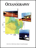
On the Cover: Daily averaged surface current vectors from the CODAR/SeaSonde HF radar network around Monterey Bay for 6 August 1994, together with satellite-derived sea surface temperatures in the range 9°C (blue) to 17°C (red). Symbols denote offshore mooring locations (red) and radar sites (black). Photographs show the phased-array antennas recently deployed in Santa Cruz (see Teague et aL, 1997, this issue), the older-style CODAR antenna deployed at MBARI in Moss Landing, and the SeaSonde antenna deployed on a Coast Guard building at Pt. Pinos near Monterey. These images were produced by G. Hatcher (MBARI) and P. Braccio (NPS).
Cover PDF
SPECIAL ISSUE FEATURES
Introduction to High-Frequency Radar: Reality and Myth
By
Jeffrey D. Paduan and
Hans C. Graber
HF Radar Instruments, Past to Present
By
Calvin C. Teague ,
John F. Vesecky , and
Daniel M. Fernandez
Synoptic Measurement of Dynamic Oceanic Features
By
Brian K. Haus ,
Hans C. Graber, and
Lynn K. Shay
Mapping Surface Currents in Monterey Bay With CODAR-Type HF Radar
By
Jeffrey D. Paduan and
Michael S. Cook
The Coastal Jet: Observations of Surface Currents Over the Oregon Continental Shelf From HF Radar
By
P. Michael Kosro ,
John A. Barth, and
P. Ted Strub
Tidal and Wind-Driven Currents From OSCR
By
David Prandle
Internal Wave-Driven Surface Currents From HF Radar
By
Lynn K. Shay
Larval Transport and Coastal Upwelling: An Application of HF Radar in Ecological Research
By
Eric P. Bjorkstedt and
Jonathan Roughgarden
Transport Patterns of Tropical Reef Fish Larvae by Spin-Off Eddies in the Straits of Florida
By
Hans C. Graber and
Claire B. Limouzy-Paris
Evolution of Bearing Determination in HF Current Mapping Radars
By
Donald E. Barrick and
Belinda J. Lipa
Validation of HF Radar Measurements
By
Rick D. Chapman and
Hans C. Graber
Shipboard Deployment of a VHF OSCR System for Measuring Offshore Currents
By
Richard A. Skop and
Nicholas J. Peters
Experience With Shipborne Measurements of Surface Current Fields by HF Radar
By
Klaus-Werner Gurgel
The Ocean Wave Directional Spectrum
By
Lucy R. Wyatt
Wave Height Measurements From HF Radar
By
Hans C. Graber and
Malcolm L. Heron
Mapping Wind Directions with HF Radar
By
Daniel M. Fernandez ,
Hans C. Graber,
Jeffrey D. Paduan, and
Donald E. Barrick
DEPARTMENTS
QUARTERDECK • High-Frequency Radar Remote Sensing: The New Revolution in Coastal Oceanography
By
Dennis B. Trizna and
Robert E. Jensen
Sponsors
U.S. Army Corps of Engineers and the Office of Naval Research